1835 - Etat détaillé des sections du plan cadastral napoléonien
Un article de GrandTerrier.
| Version du 27 décembre ~ kerzu 2016 à 08:26 (modifier) GdTerrier (Discuter | contributions) ← Différence précédente |
Version du 27 décembre ~ kerzu 2016 à 08:35 (modifier) (undo) GdTerrier (Discuter | contributions) Différence suivante → |
||
| Ligne 49: | Ligne 49: | ||
| ==Documents originaux== | ==Documents originaux== | ||
| - | + | {|width=870 | |
| - | Images ci-dessous fournies par le service des Archives Communales d'Ergué-Gabéric. Le 2e exemplaire de l'état de section est conservé aux Archives Départementales du Finistère sous la cote=3 P 54 / 2. | + | |width=48% valign=top {{jtfy}}| |
| - | + | Les images ci-dessous sont fournies par le service des Archives Communales d'Ergué-Gabéric. | |
| + | |width=4% valign=top {{jtfy}}| | ||
| + | |width=48% valign=top {{jtfy}}| | ||
| + | Le 2e exemplaire de l'état de section est conservé aux Archives Départementales du Finistère sous la cote 3 P 54 / 2. | ||
| + | |} | ||
| <gallery caption="Section A - Squividan"> | <gallery caption="Section A - Squividan"> | ||
| Image:Cadastre1835-EtatSection-A-00.jpg|couv | Image:Cadastre1835-EtatSection-A-00.jpg|couv | ||
| Ligne 133: | Ligne 137: | ||
| Image:Cadastre1835-EtatSection-C-01.jpg|p.1 | Image:Cadastre1835-EtatSection-C-01.jpg|p.1 | ||
| Image:Cadastre1835-EtatSection-C-02.jpg|p.2 | Image:Cadastre1835-EtatSection-C-02.jpg|p.2 | ||
| + | Image:Cadastre1835-EtatSection-C-03.jpg|p.3 | ||
| + | Image:Cadastre1835-EtatSection-C-04.jpg|p.4 | ||
| + | Image:Cadastre1835-EtatSection-C-05.jpg|p.5 | ||
| + | Image:Cadastre1835-EtatSection-C-06.jpg|p.6 | ||
| + | Image:Cadastre1835-EtatSection-C-07.jpg|p.7 | ||
| + | Image:Cadastre1835-EtatSection-C-08.jpg|p.8 | ||
| + | Image:Cadastre1835-EtatSection-C-09.jpg|p.9 | ||
| + | Image:Cadastre1835-EtatSection-C-10.jpg|p.10 | ||
| + | Image:Cadastre1835-EtatSection-C-11.jpg|p.11 | ||
| + | Image:Cadastre1835-EtatSection-C-12.jpg|p.12 | ||
| + | Image:Cadastre1835-EtatSection-C-13.jpg|p.13 | ||
| + | Image:Cadastre1835-EtatSection-C-14.jpg|p.14 | ||
| + | Image:Cadastre1835-EtatSection-C-15.jpg|p.15 | ||
| + | Image:Cadastre1835-EtatSection-C-16.jpg|p.16 | ||
| + | Image:Cadastre1835-EtatSection-C-17.jpg|p.17 | ||
| + | Image:Cadastre1835-EtatSection-C-18.jpg|p.18 | ||
| + | Image:Cadastre1835-EtatSection-C-19.jpg|p.19 | ||
| + | Image:Cadastre1835-EtatSection-C-20.jpg|p.20 | ||
| + | Image:Cadastre1835-EtatSection-C-21.jpg|p.21 | ||
| + | Image:Cadastre1835-EtatSection-C-22.jpg|p.22 | ||
| + | Image:Cadastre1835-EtatSection-C-23.jpg|p.23 | ||
| + | Image:Cadastre1835-EtatSection-C-24.jpg|p.24 | ||
| + | Image:Cadastre1835-EtatSection-C-25.jpg|p.25 | ||
| + | Image:Cadastre1835-EtatSection-C-26.jpg|p.26 | ||
| + | Image:Cadastre1835-EtatSection-C-27.jpg|p.27 | ||
| + | Image:Cadastre1835-EtatSection-C-28.jpg|p.28 | ||
| + | Image:Cadastre1835-EtatSection-C-29.jpg|p.29 | ||
| + | Image:Cadastre1835-EtatSection-C-30.jpg|p.30 | ||
| + | Image:Cadastre1835-EtatSection-C-31.jpg|p.31 | ||
| + | Image:Cadastre1835-EtatSection-C-32.jpg|p.32 | ||
| + | Image:Cadastre1835-EtatSection-C-33.jpg|p.33 | ||
| + | Image:Cadastre1835-EtatSection-C-34.jpg|p.34 | ||
| + | Image:Cadastre1835-EtatSection-C-35.jpg|p.35 | ||
| + | Image:Cadastre1835-EtatSection-C-36.jpg|p.36 | ||
| + | Image:Cadastre1835-EtatSection-C-37.jpg|p.37 | ||
| + | Image:Cadastre1835-EtatSection-C-38.jpg|p.38 | ||
| + | Image:Cadastre1835-EtatSection-C-39.jpg|p.39 | ||
| + | Image:Cadastre1835-EtatSection-C-40.jpg|p.40 | ||
| + | Image:Cadastre1835-EtatSection-C-41.jpg|p.41 | ||
| + | Image:Cadastre1835-EtatSection-C-42.jpg|p.42 | ||
| + | Image:Cadastre1835-EtatSection-C-43.jpg|p.43 | ||
| + | Image:Cadastre1835-EtatSection-C-44.jpg|recap | ||
| </gallery> | </gallery> | ||
Version du 27 décembre ~ kerzu 2016 à 08:35
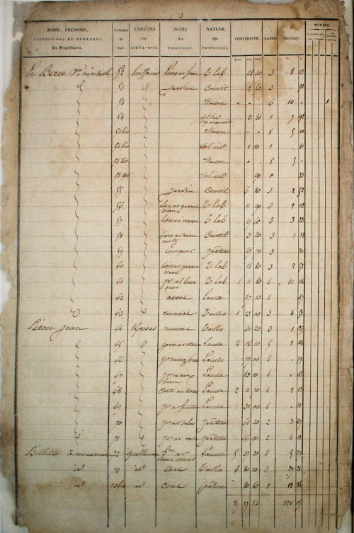
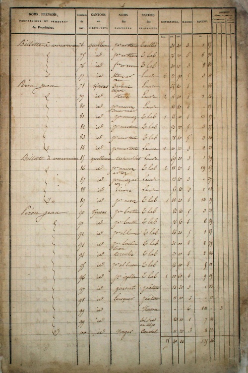
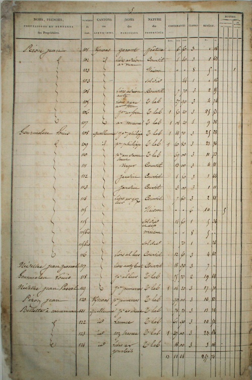
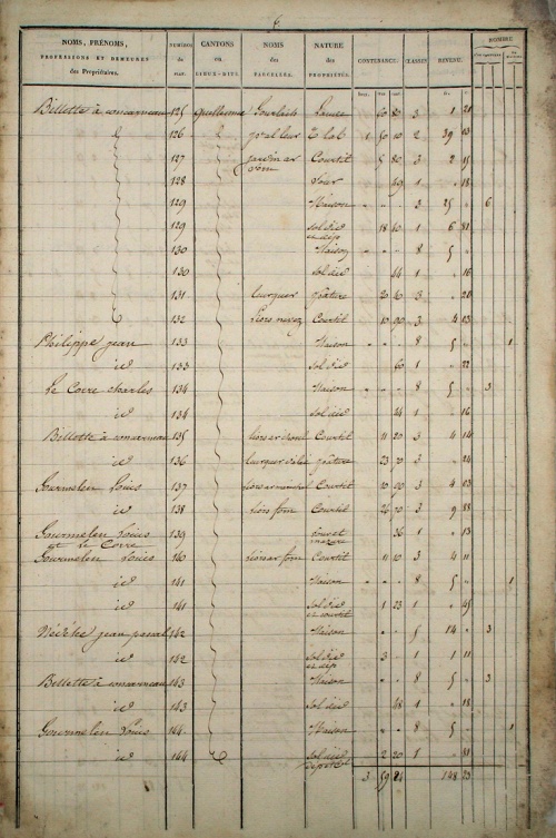
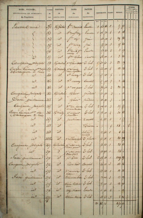
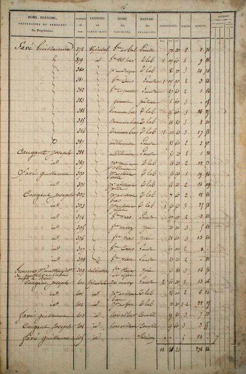
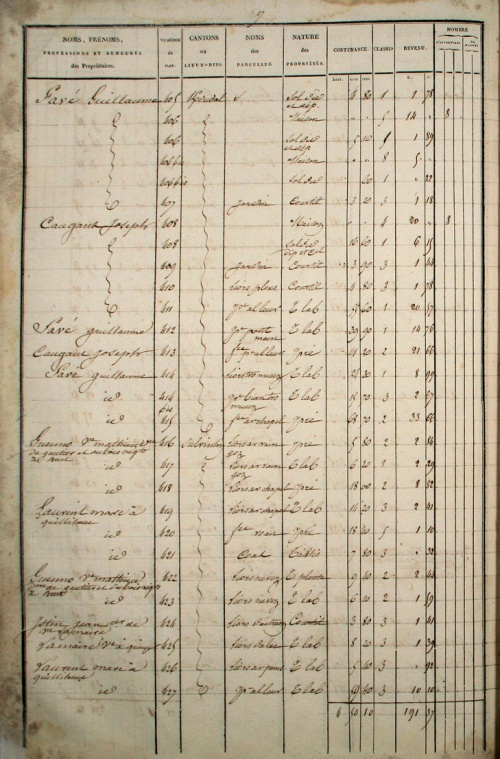
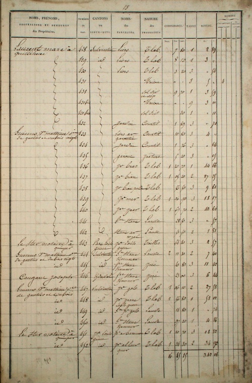
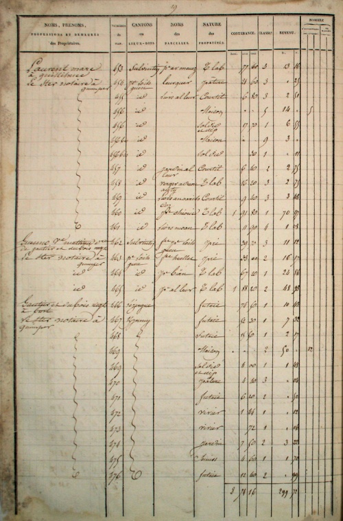
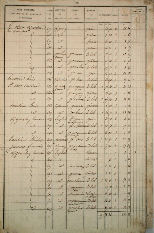
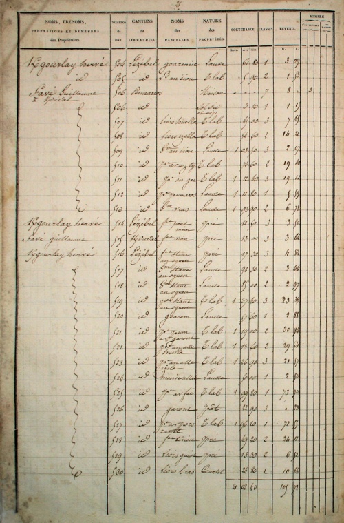
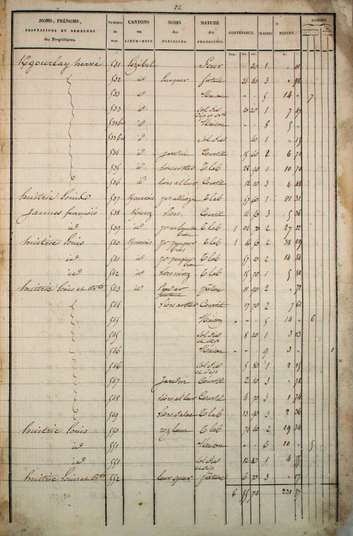
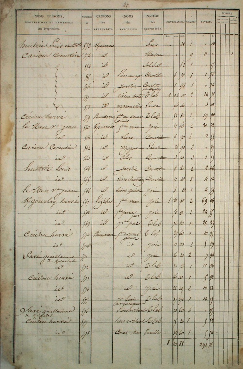
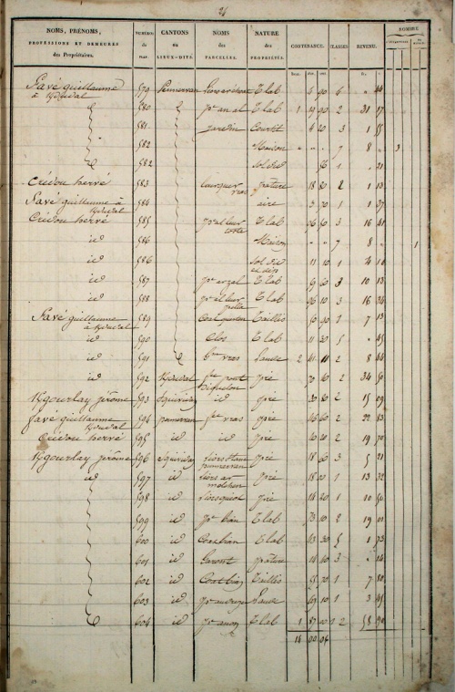
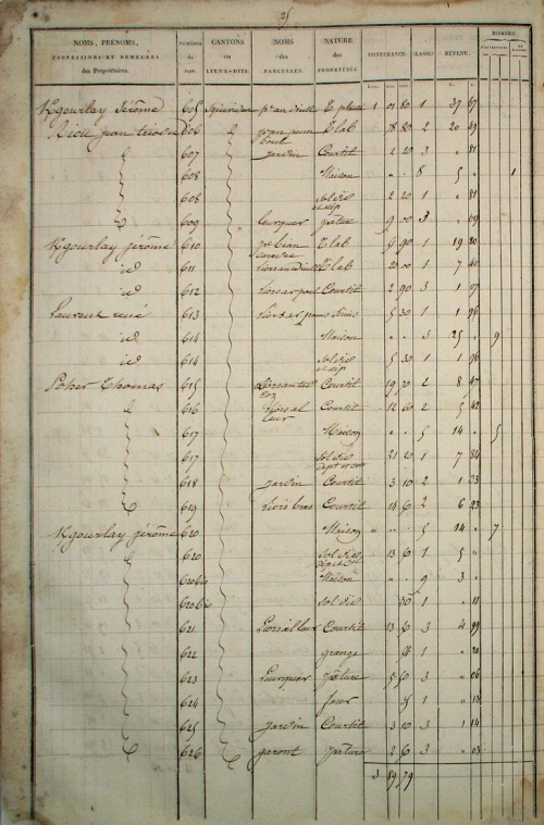
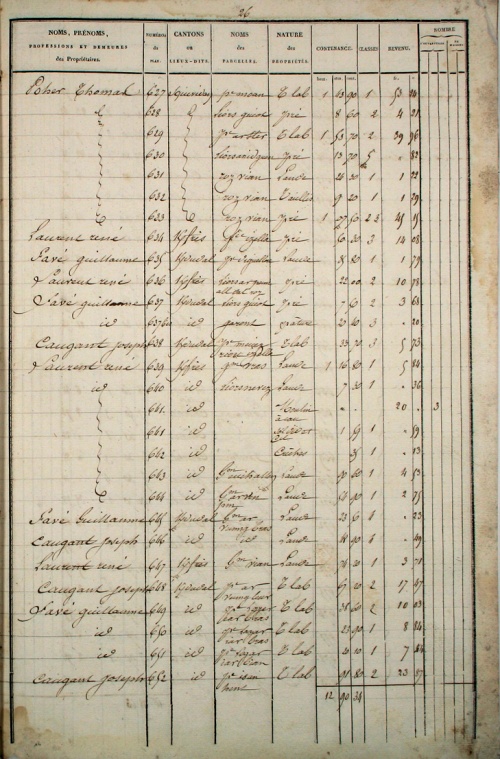
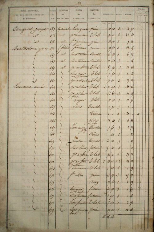
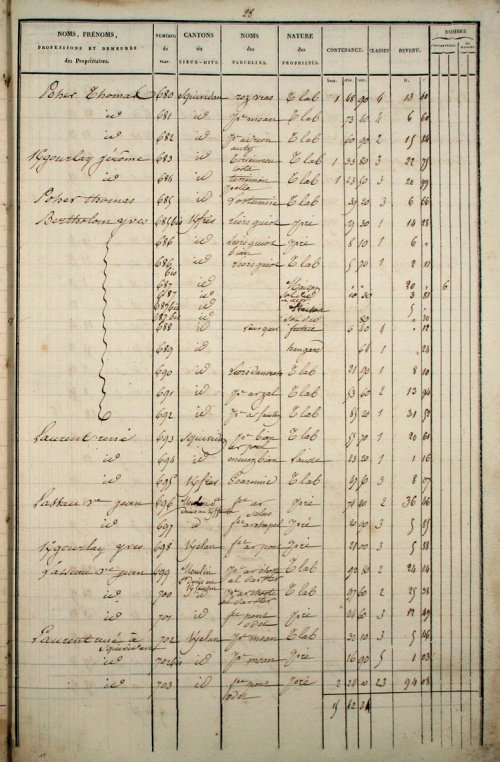
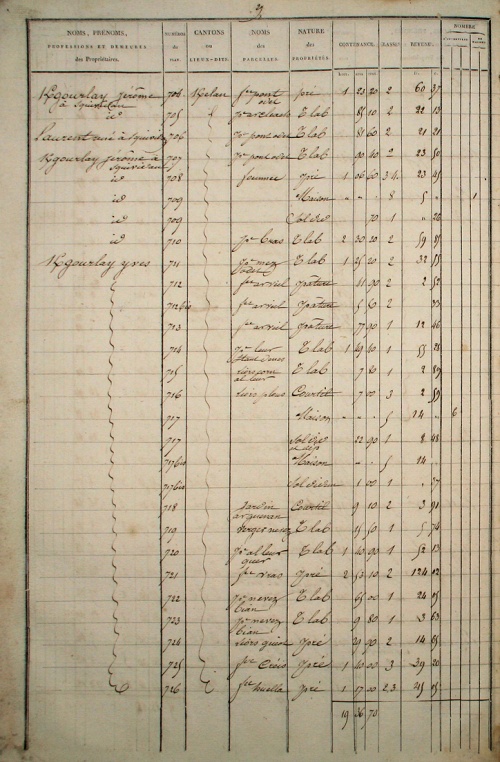
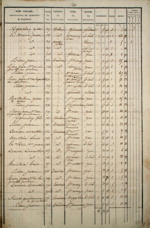
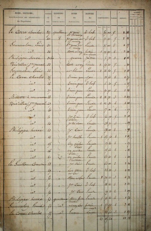
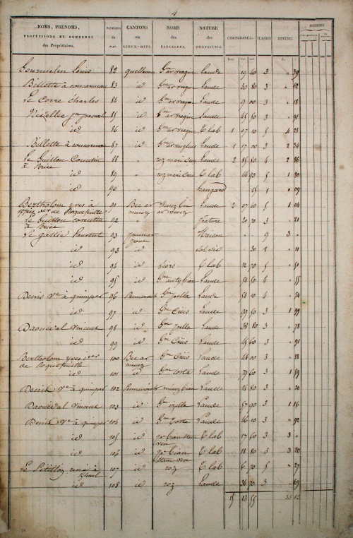
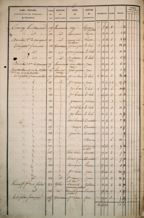
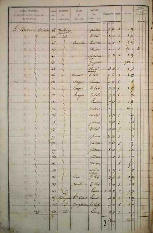
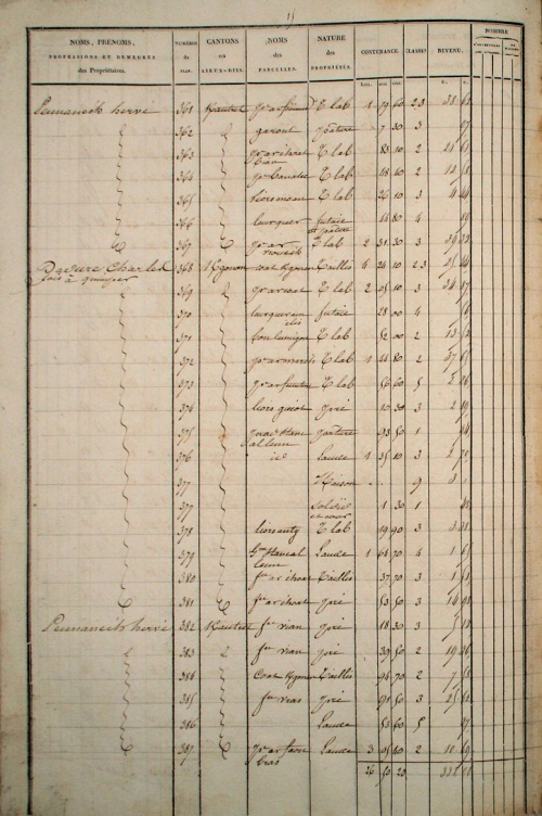
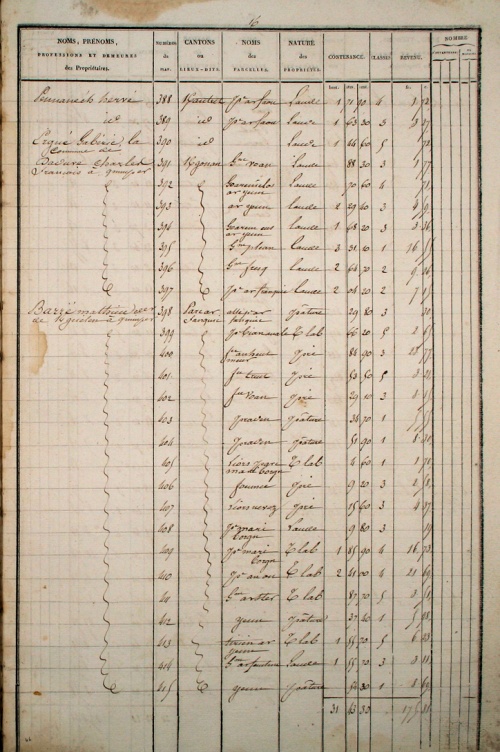
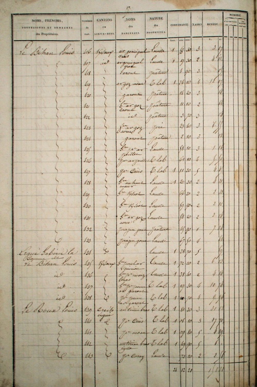
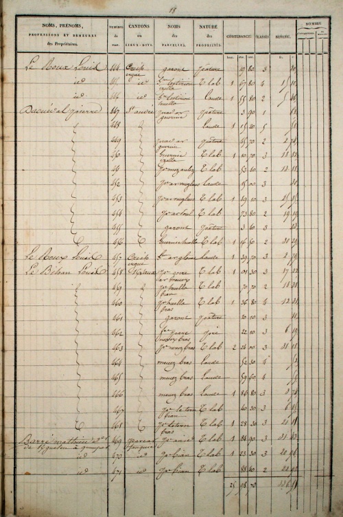
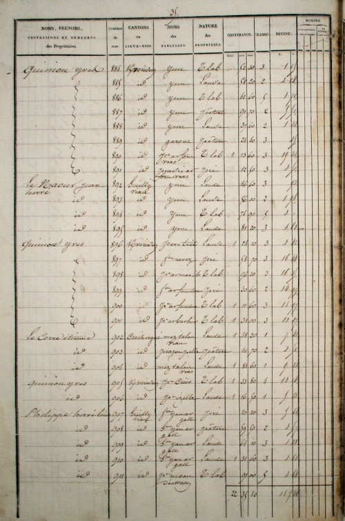
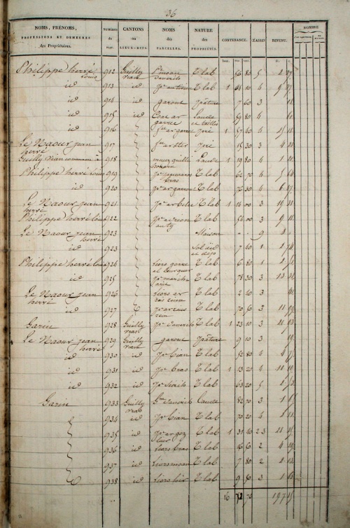
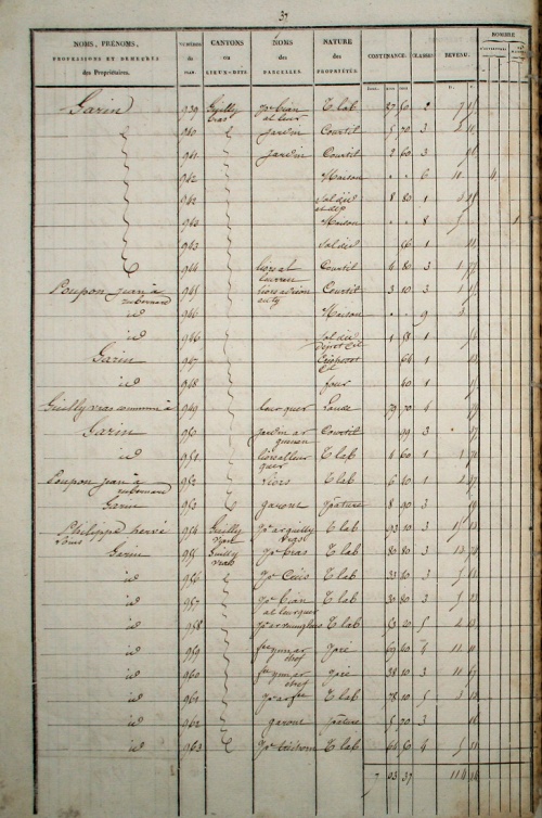
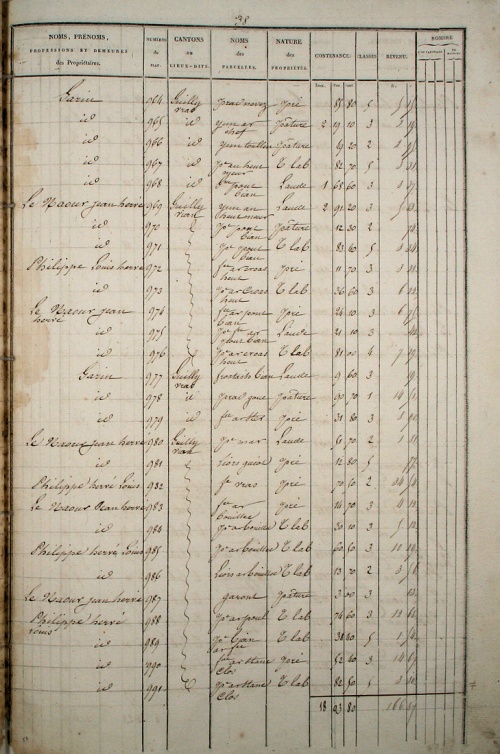
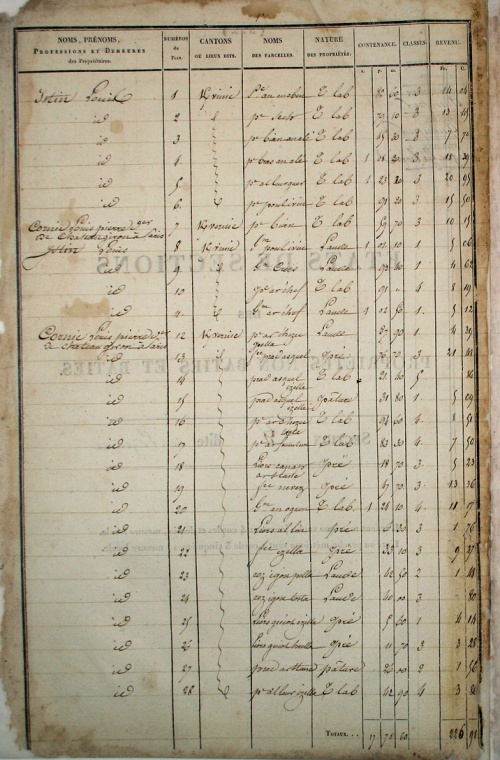
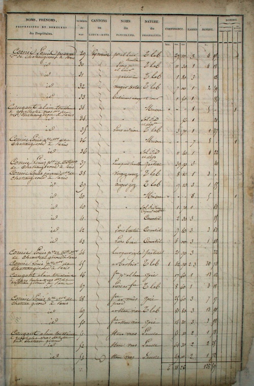
| Transcription de l'état des section du plan cadastral de 1835 en continuation des travaux initiés par Henri Chauveur [1] en 2005-2008.
Mise en base de données ... Autres lectures : « 1835-1914 - Tables alphabétiques des propriétaires enregistrés dans la matrice cadastrale » ¤ « 1834 - Le plan cadastral parcellaire Napoléonien » ¤ |  |
1 Présentation
2 Transcriptions
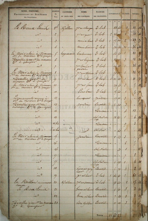
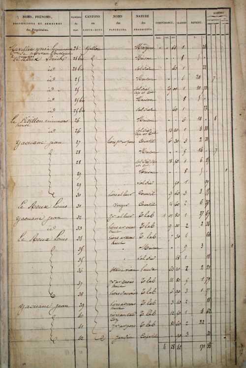
Section A - Squividan
Plans : [Feuille 1] [Feuille 2] [Feuille 3] [Feuille 4]
Section B - Sulvintin
Plans : [Feuille 1] [Feuille 2]
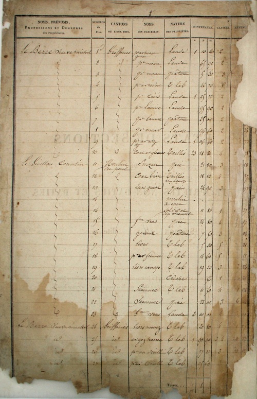
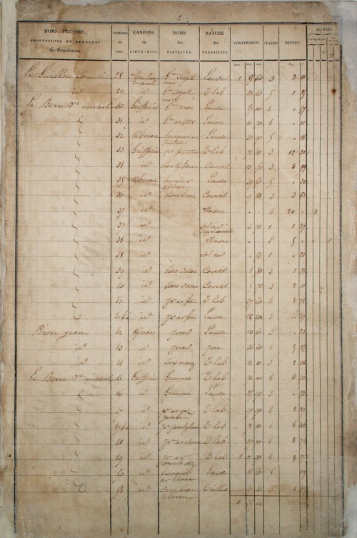
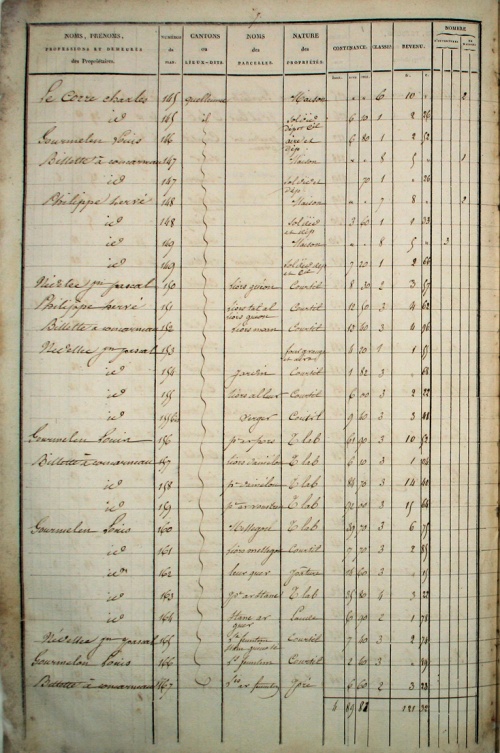
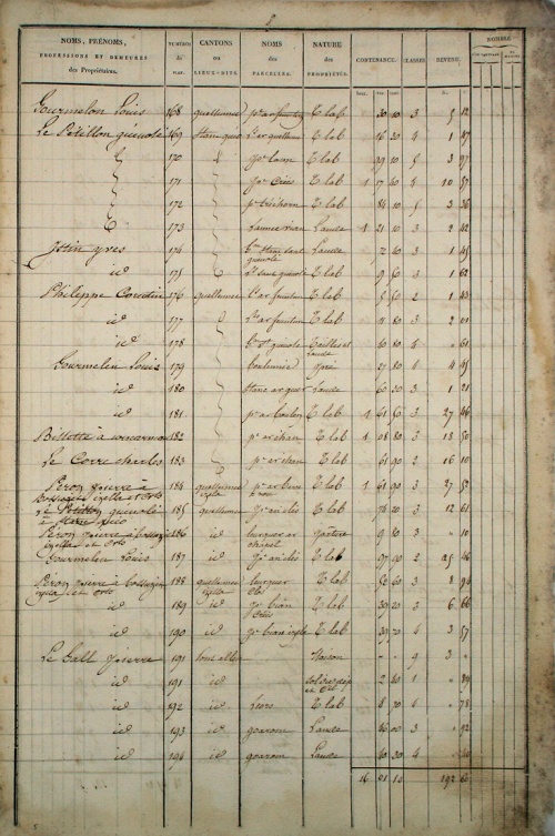
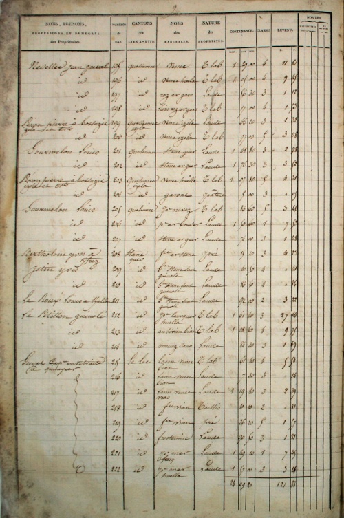
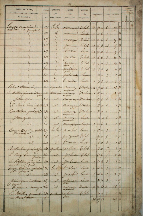
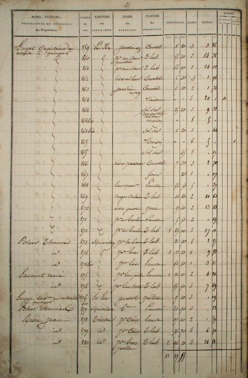
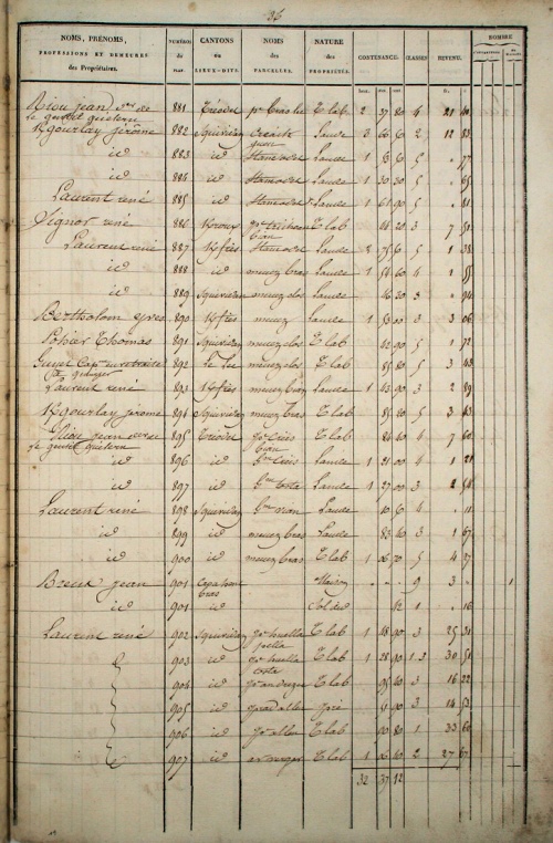
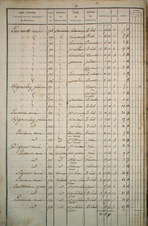
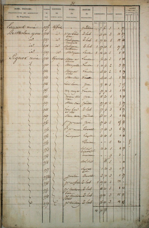
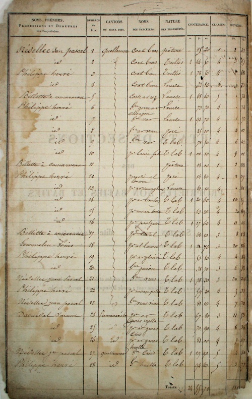
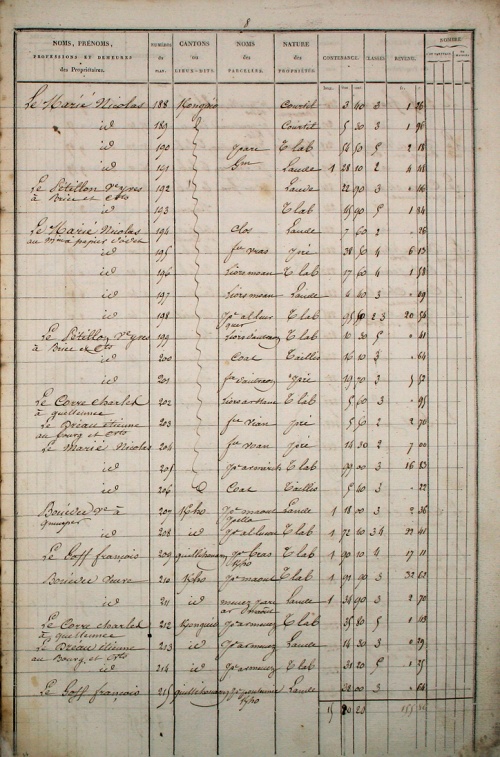
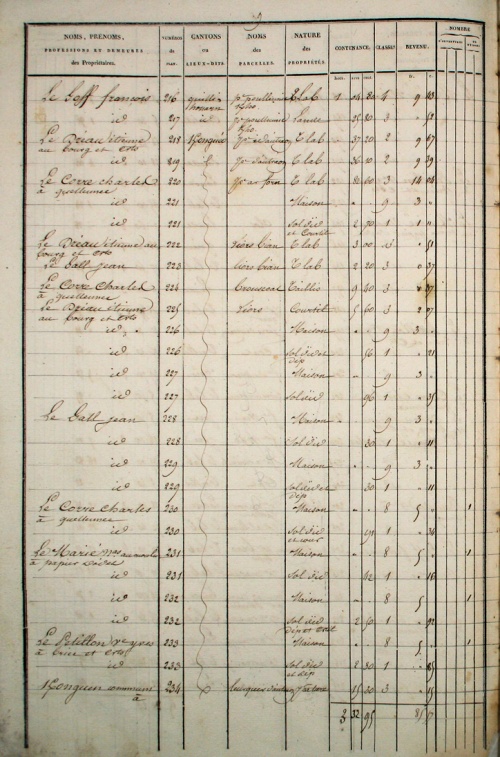
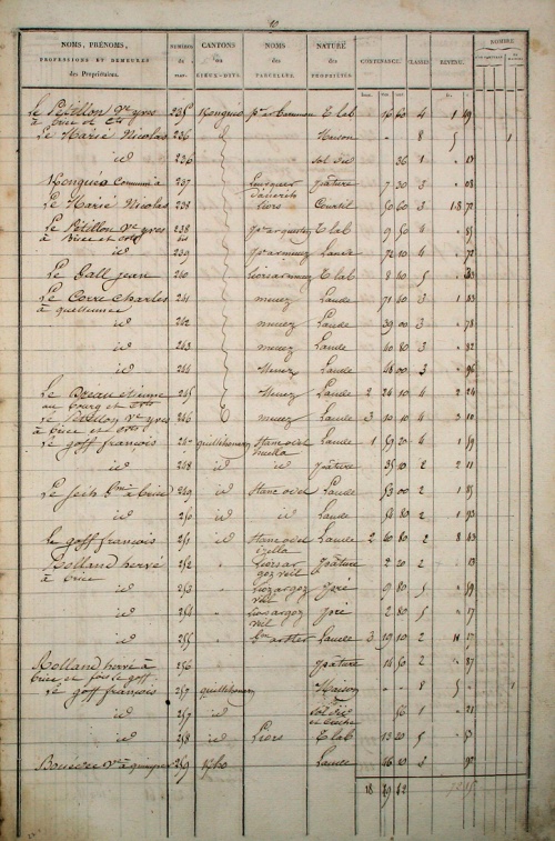
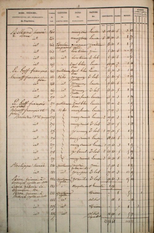
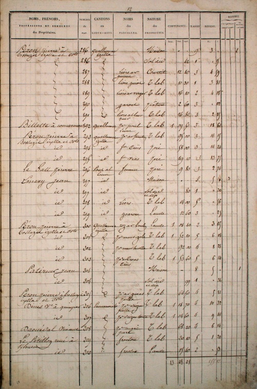
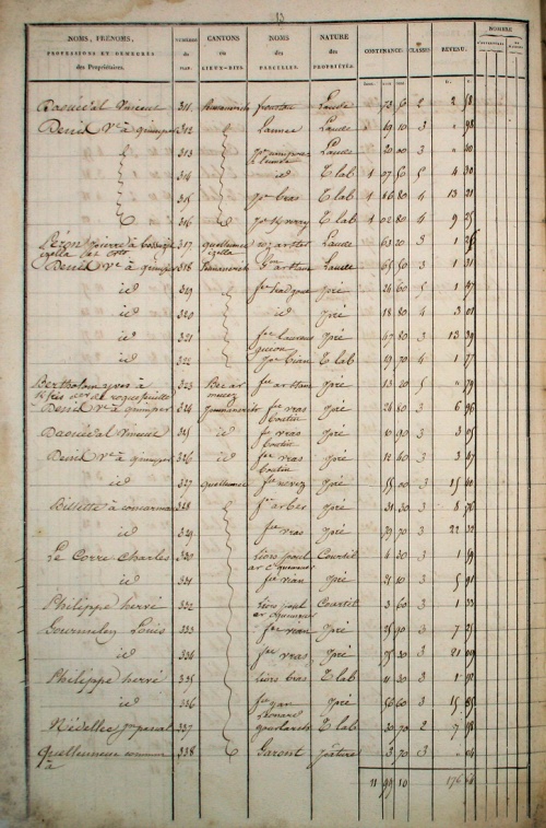
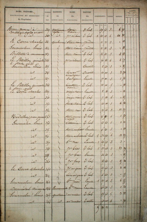
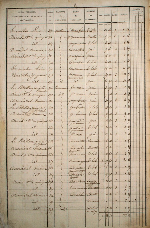
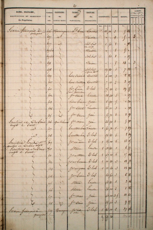
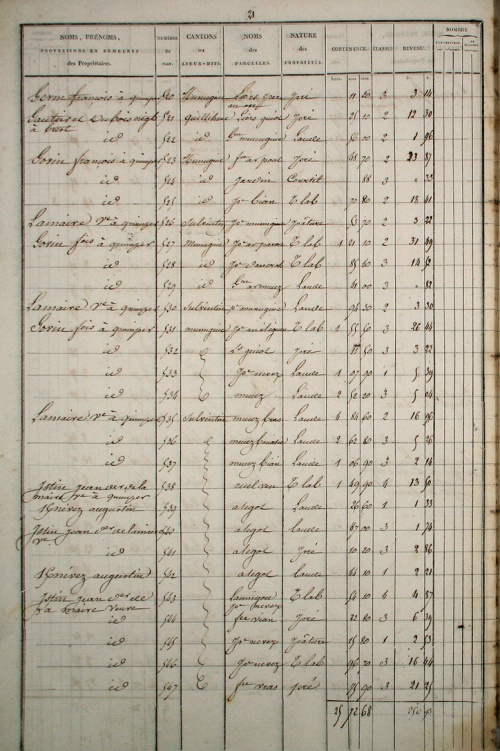
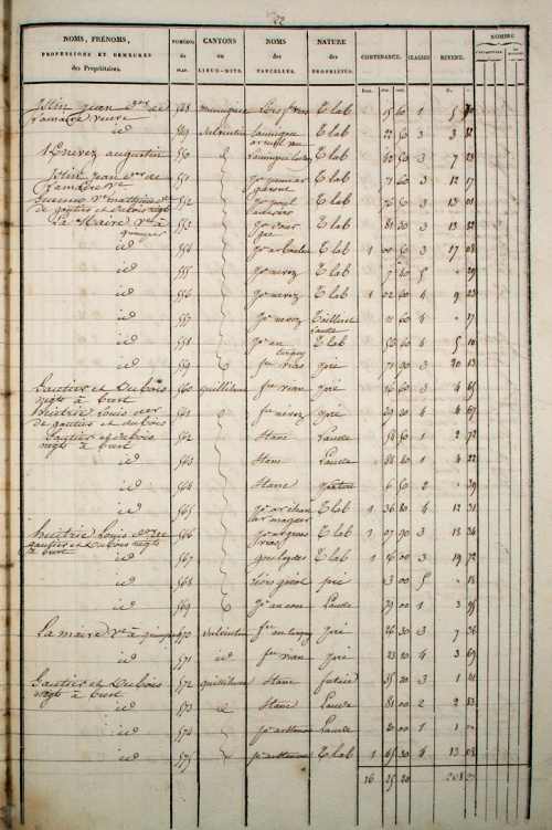
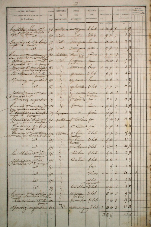
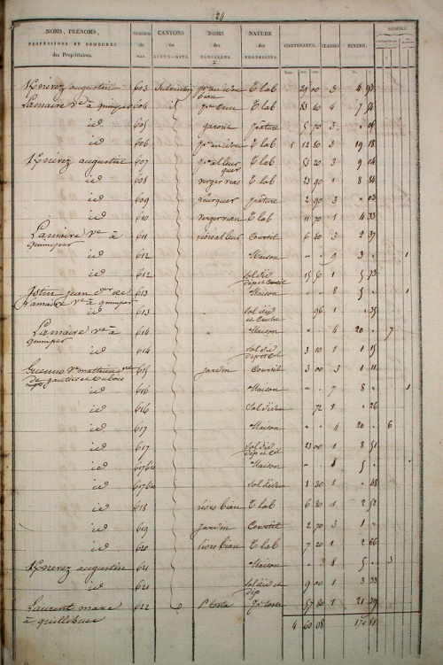
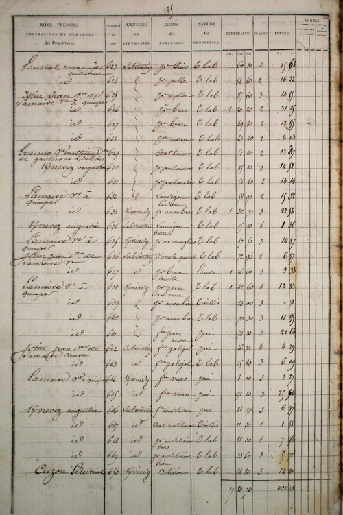
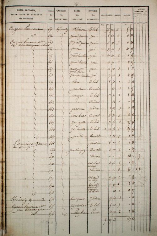
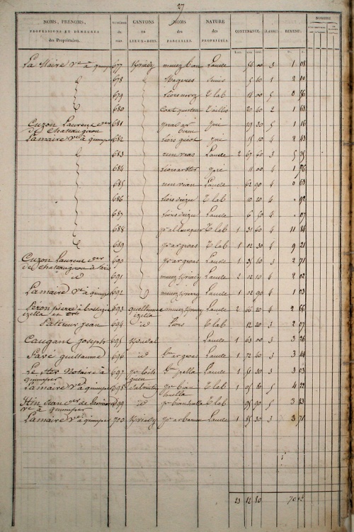
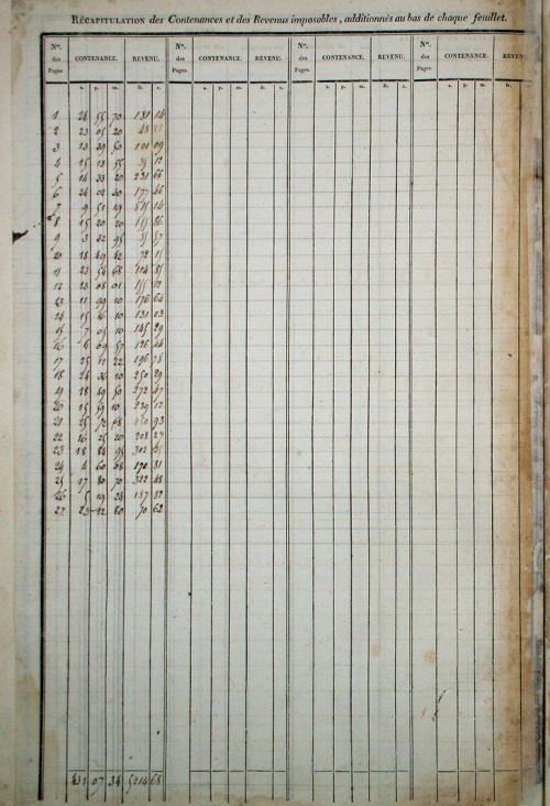
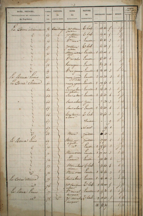
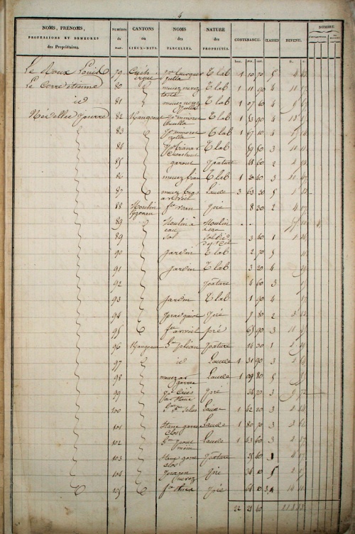
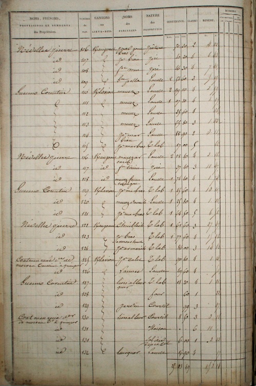
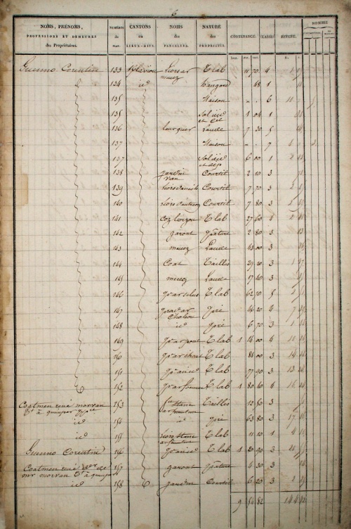
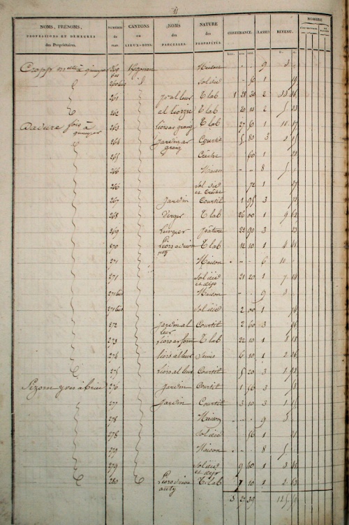
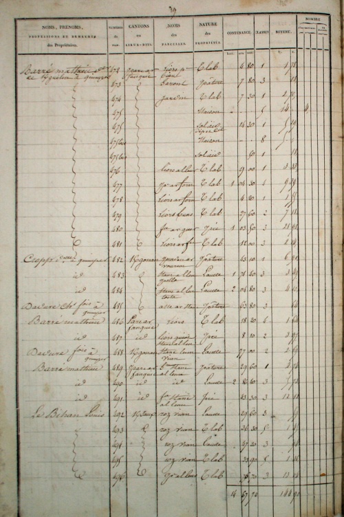
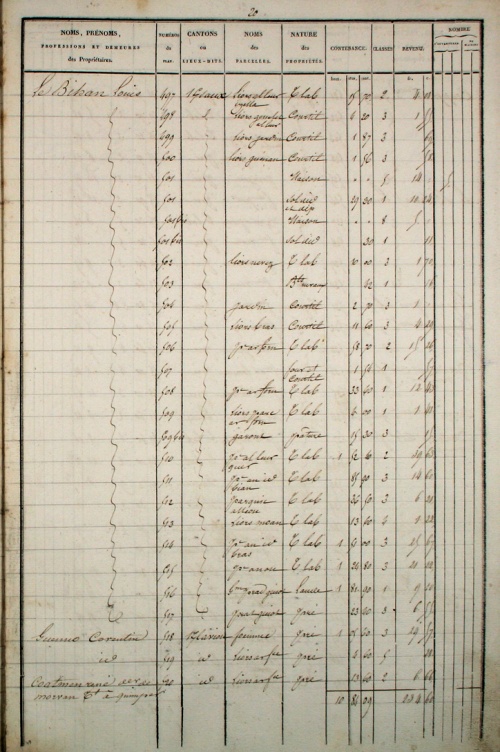
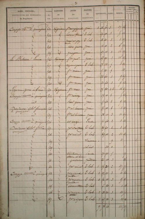
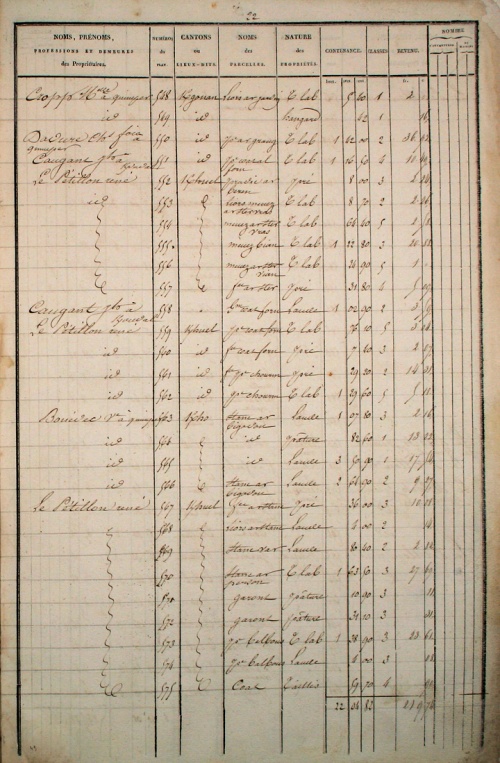
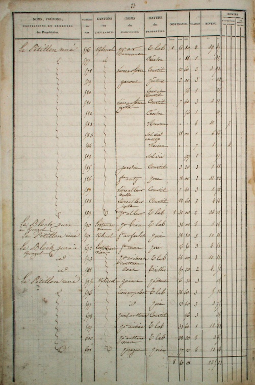
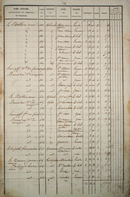
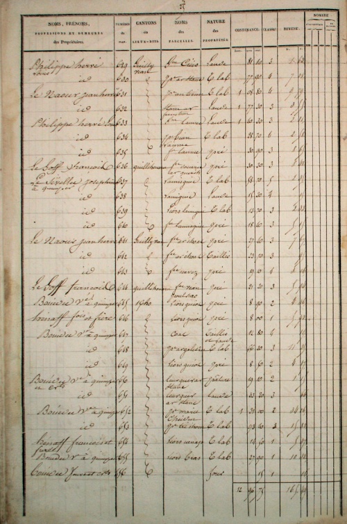
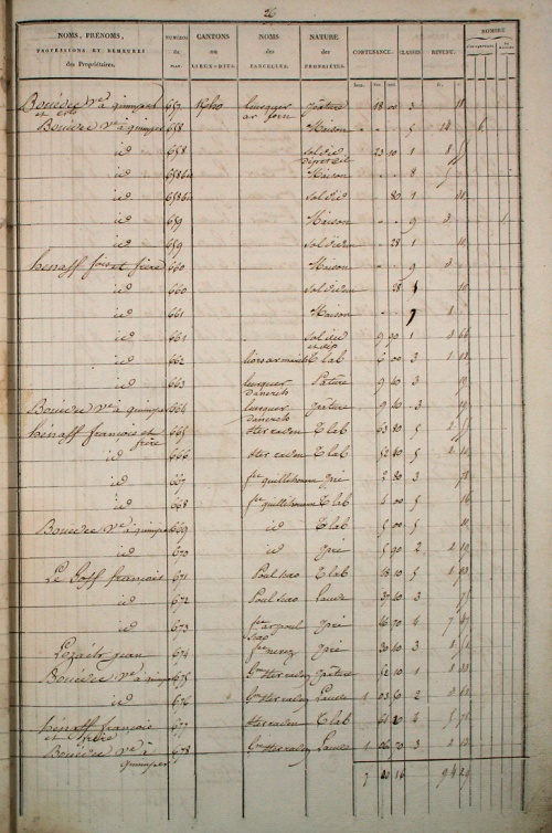
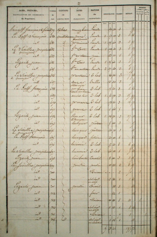
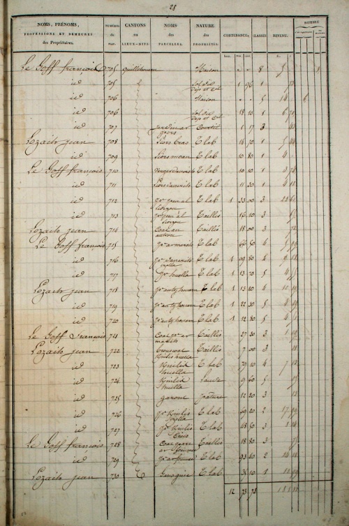
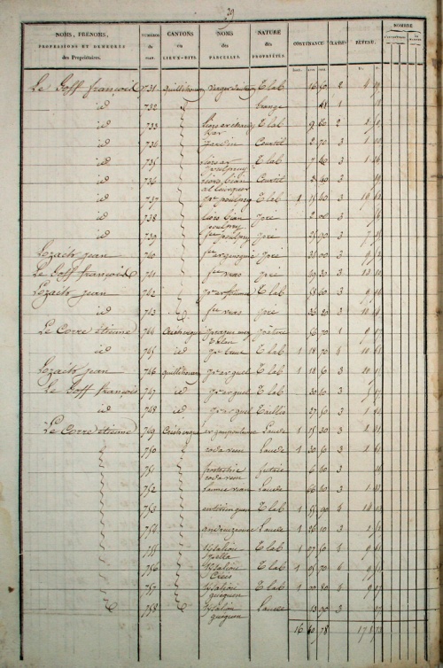
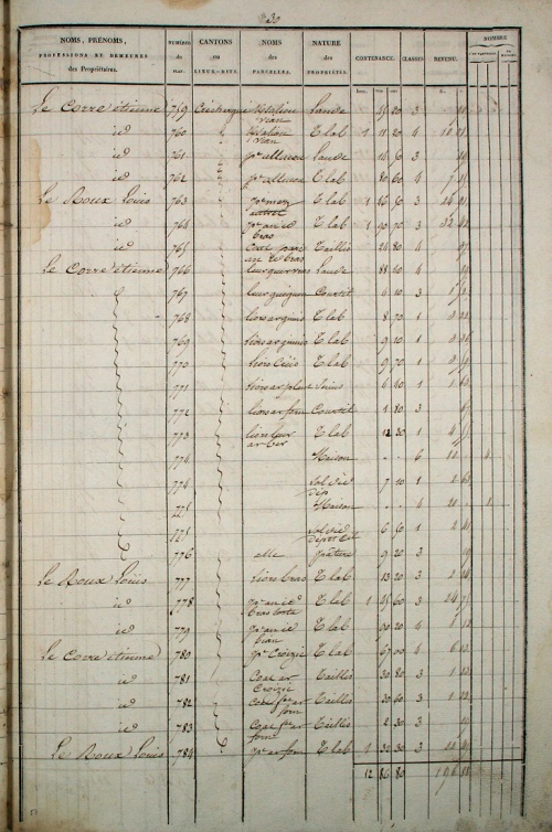
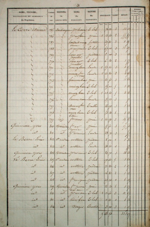
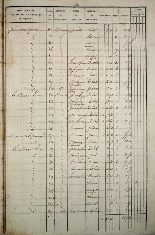
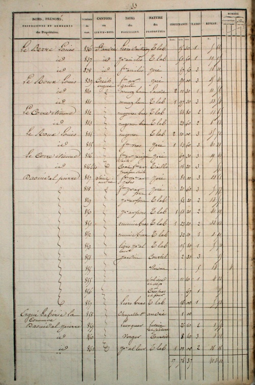
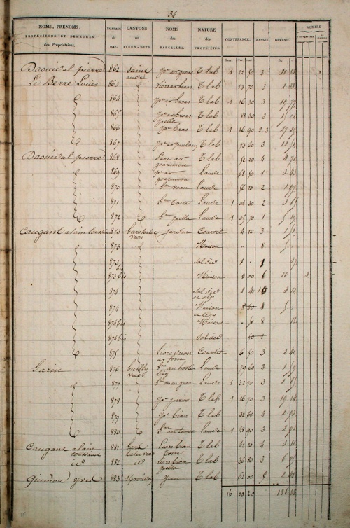
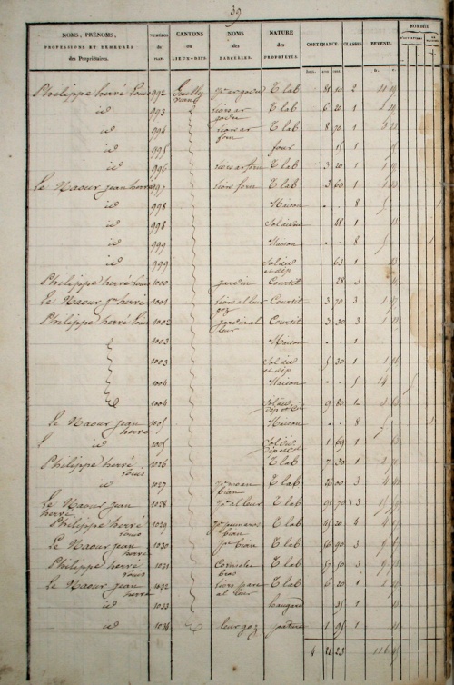
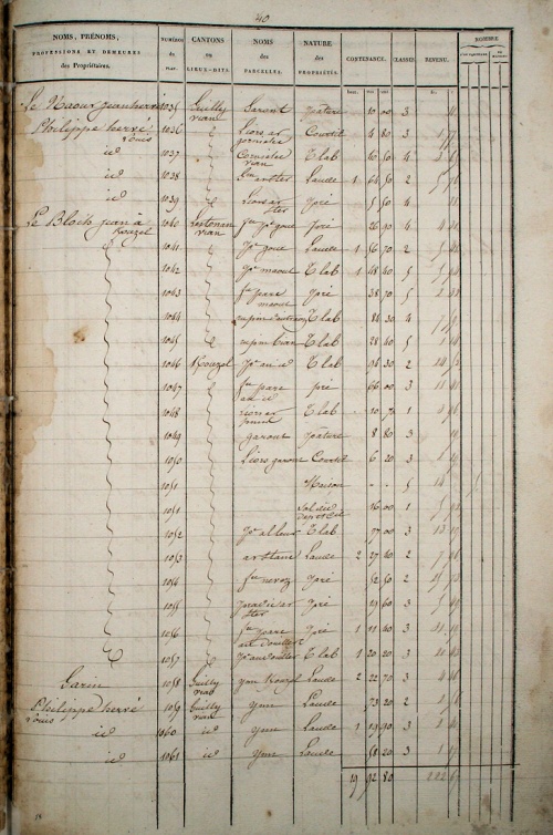
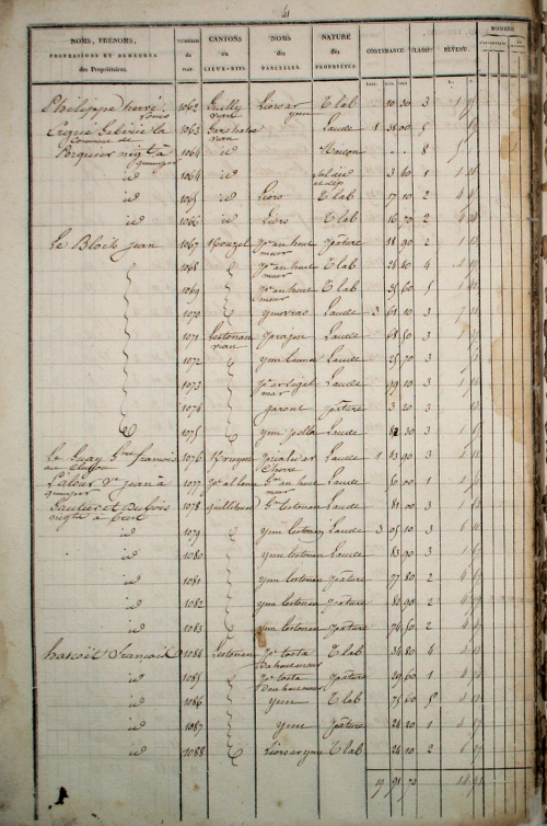
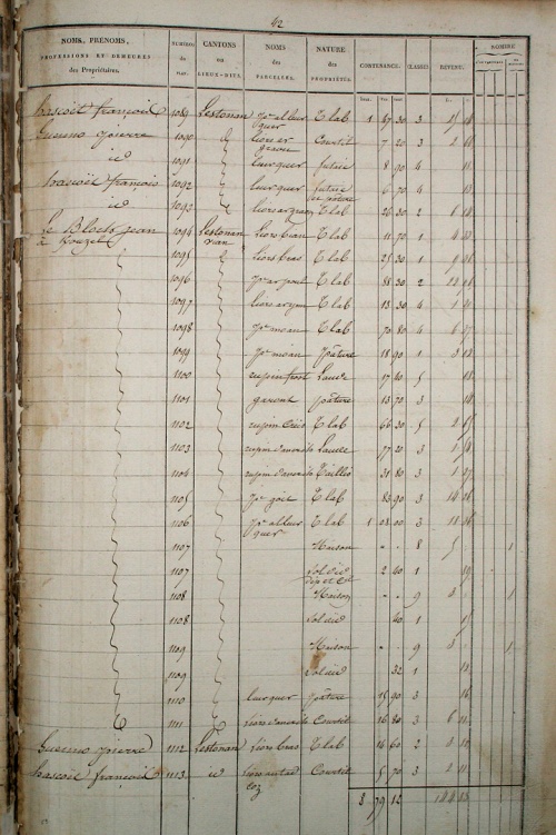
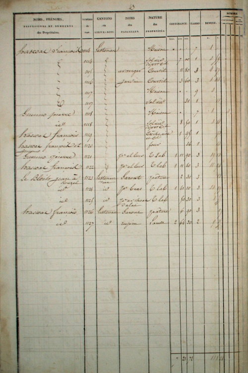
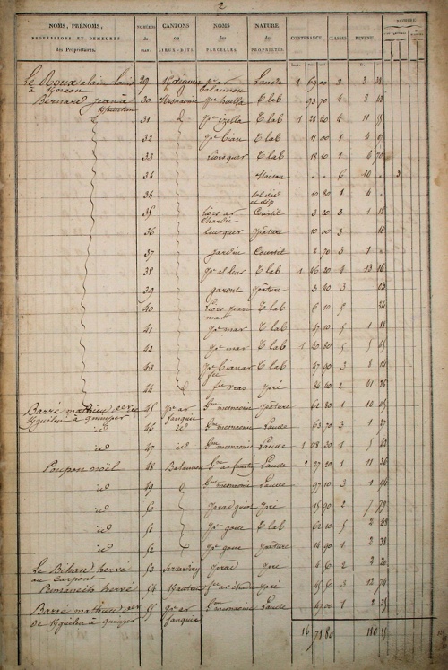
Section C - Saint-André
Plans : [Feuille 1] [Feuille 2] [Feuille 3]
Section D - Niverrot
Plans : [Feuille 1] [Feuille 2]
Section E - Lokeltaz
Plans : [Feuille 1] [Feuille 2] [Feuille 3]
Section F - Bourg
Plans : [Feuille 1-Partie 1] [Feuille 1-Partie 2] [Feuille 2]
Section G - Lezergué
Plans : [Feuille 1] [Feuille 2] [Feuille 3]
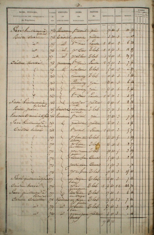
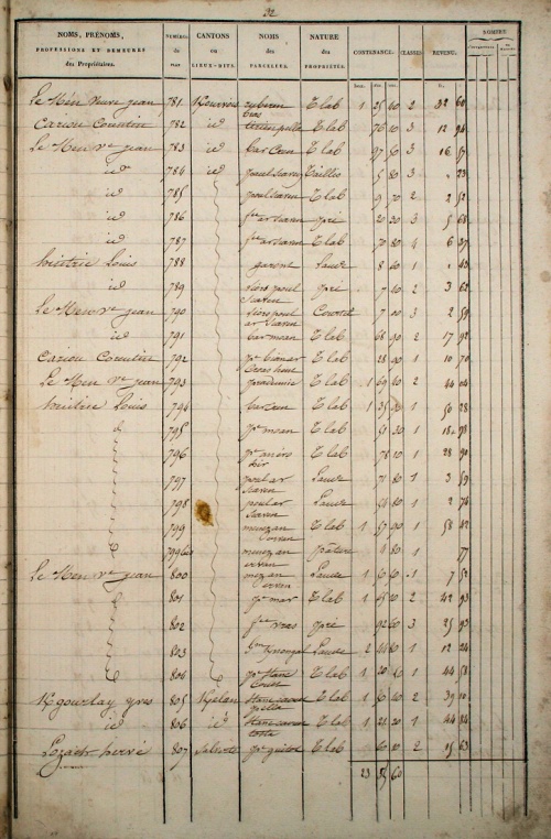
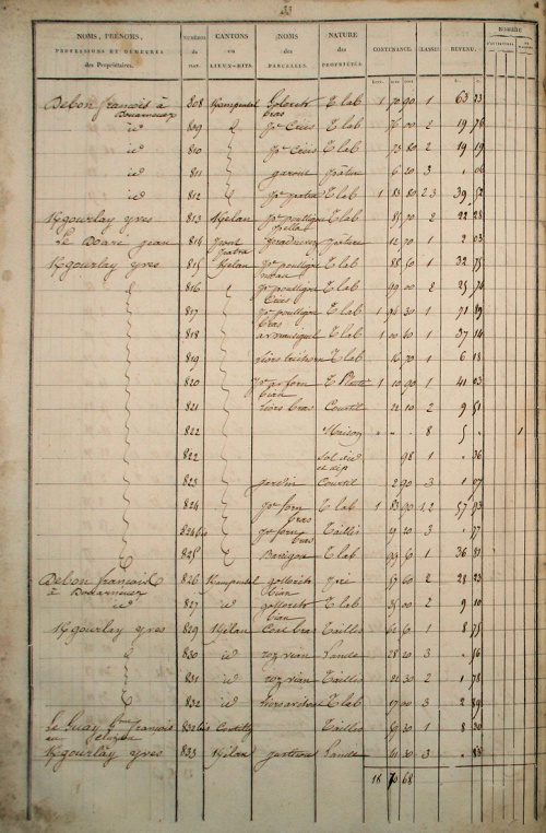
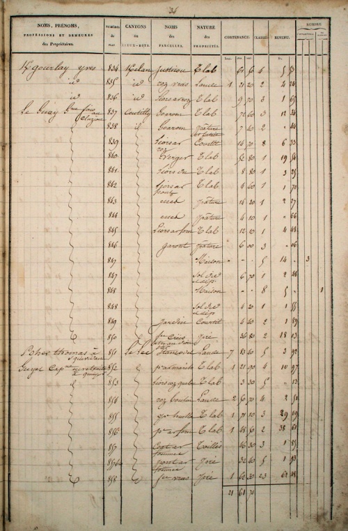
3 Documents originaux
|
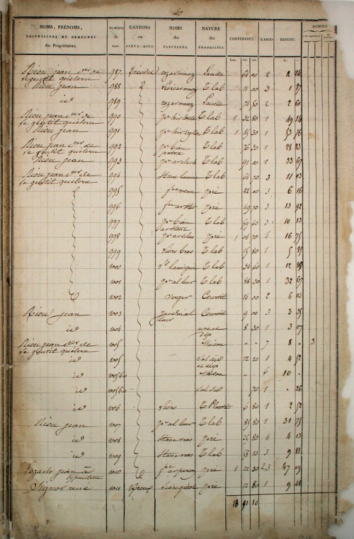
Les images ci-dessous sont fournies par le service des Archives Communales d'Ergué-Gabéric. |
Le 2e exemplaire de l'état de section est conservé aux Archives Départementales du Finistère sous la cote 3 P 54 / 2. |
 Section A - Squividan Section A - Squividan | |||||
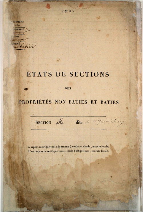 couv |
 p.1 |
 p.2 |
 p.3 |
 p.4 |
 p.5 |
 p.6 |
 p.7 |
 p.8 |
 p.9 |
 p.10 |
 p.11 |
 p.12 |
 p.13 |
 p.14 |
 p.15 |
 p.16 |
 p.17 |
 p.18 |
 p.19 |
 p.20 |
 p.21 |
 p.22 |
 p.23 |
 p.24 |
 p.25 |
 p.26 |
 p.27 |
 p.28 |
 p.29 |
 p.30 |
 p.31 |
 p.32 |
 p.33 |
 p.34 |
 p.35 |
 p.36 |
 p.37 |
 p.38 |
 p.39 |
 p.40 |
 p.41 |
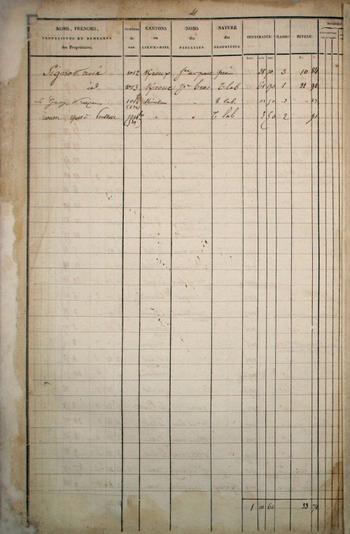
| Section B - Sulvintin | |||||
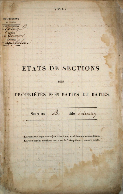 couv |
 p.1 |
 p.2 |
 p.3 |
 p.4 |
 p.5 |
 p.6 |
 p.7 |
 p.8 |
 p.9 |
 p.10 |
 p.11 |
 p.12 |
 p.13 |
 p.14 |
 p.15 |
 p.16 |
 p.17 |
 p.18 |
 p.19 |
 p.20 |
 p.21 |
 p.22 |
 p.23 |
 p.24 |
 p.25 |
 p.26 |
 p.27 |
 recap |
|
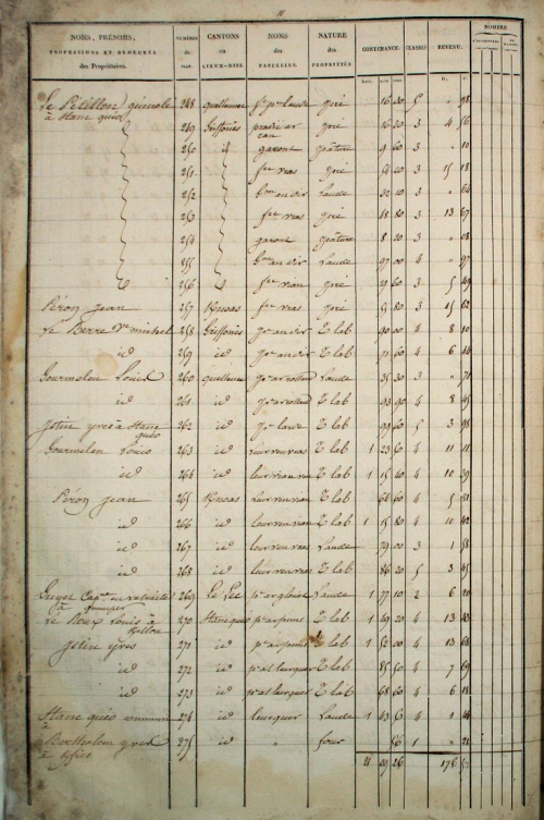
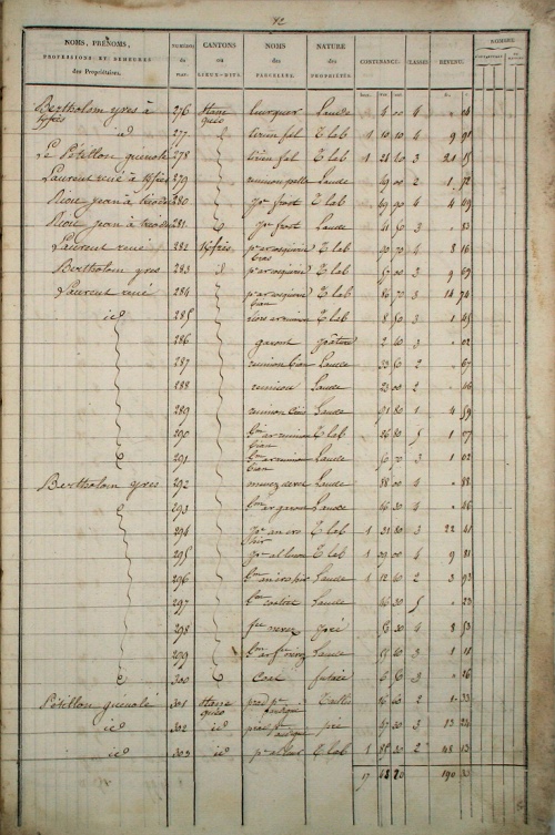
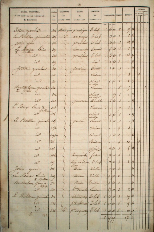
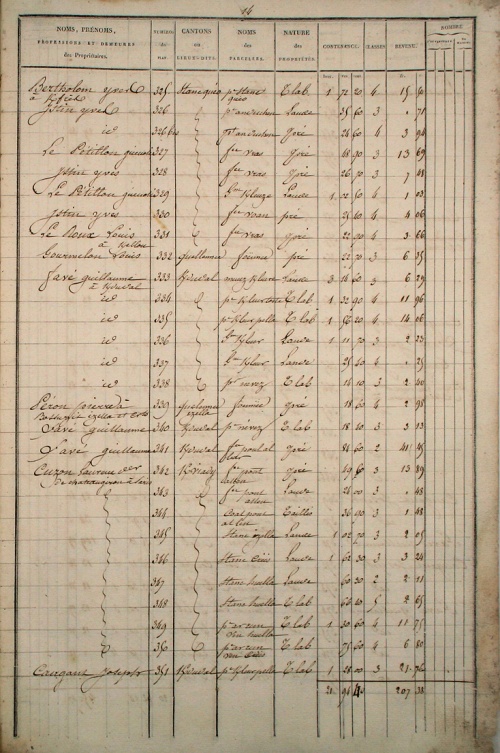
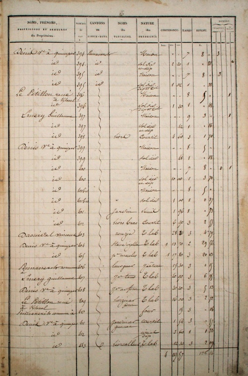
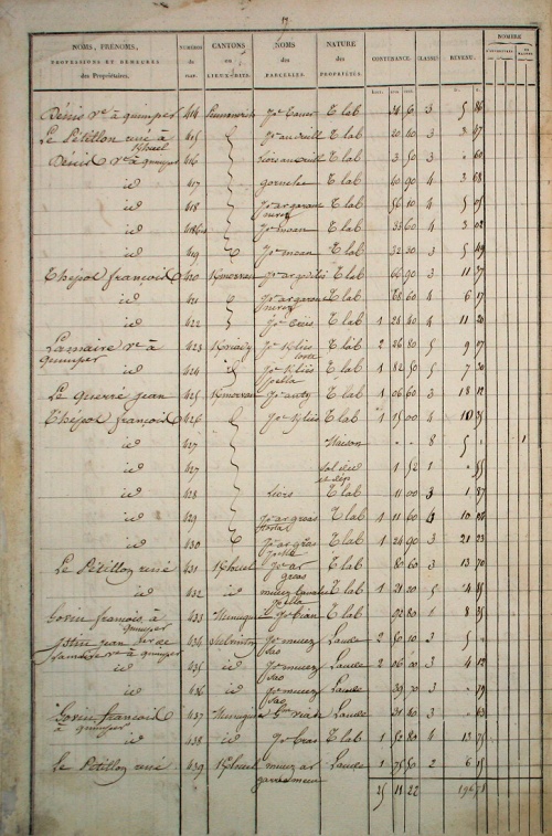
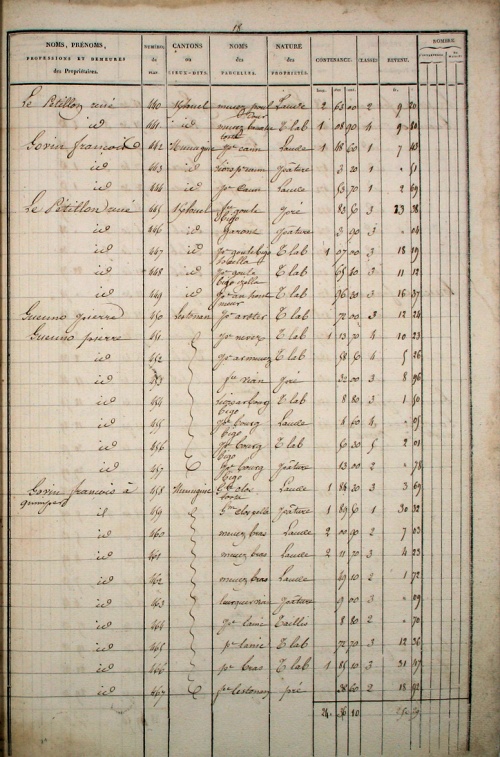
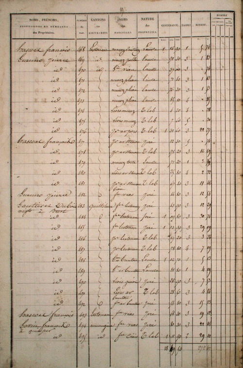
| Section C - Saint-André | |||||
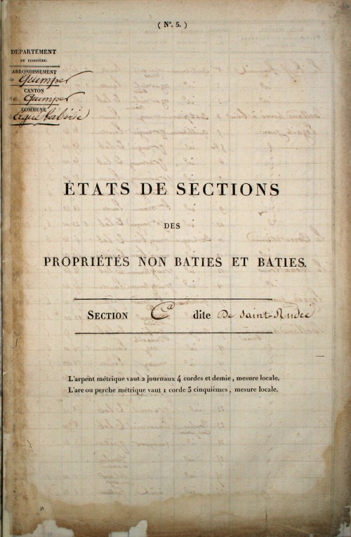 couv |
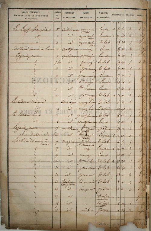 p.1 |
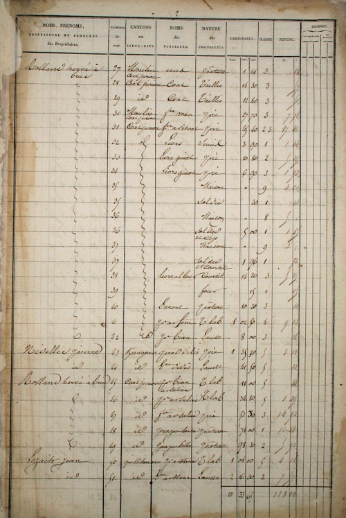 p.2 |
 p.3 |
 p.4 |
 p.5 |
 p.6 |
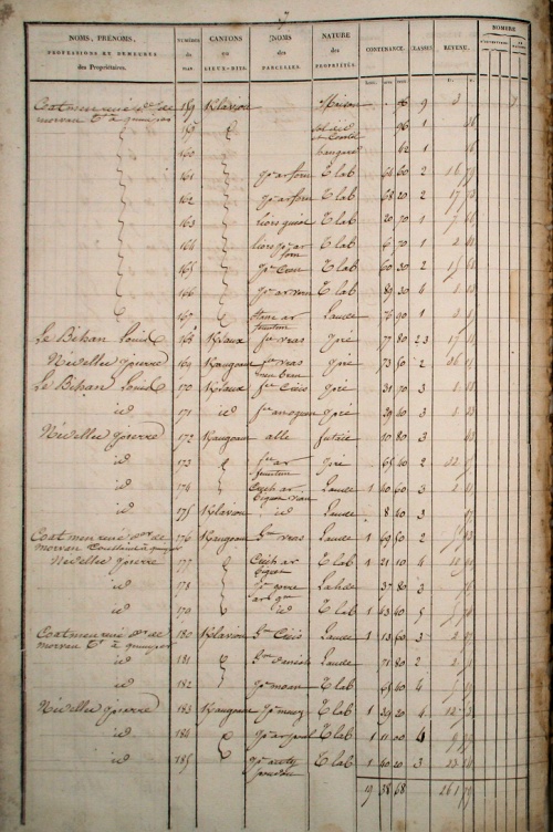 p.7 |
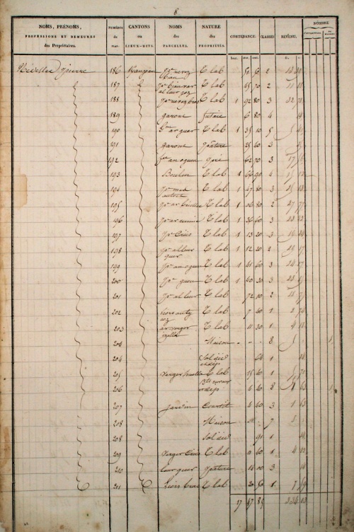 p.8 |
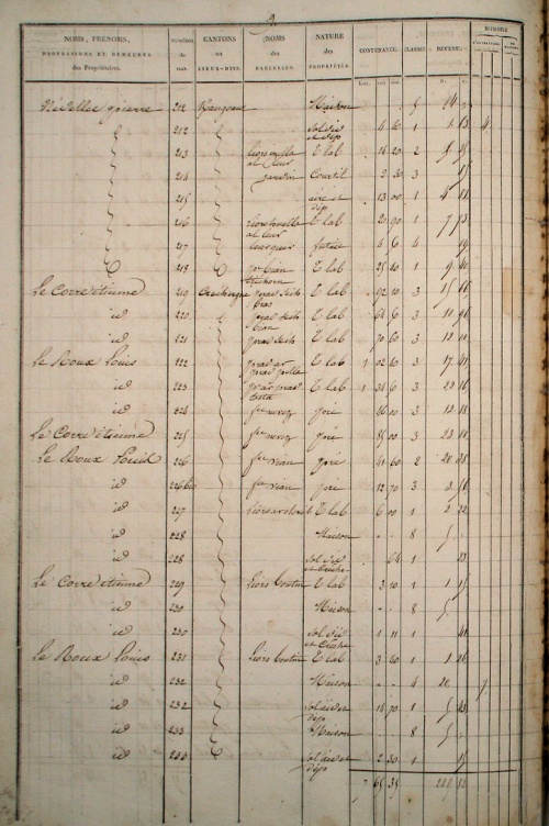 p.9 |
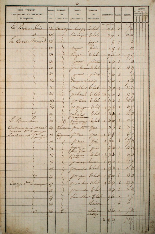 p.10 |
 p.11 |
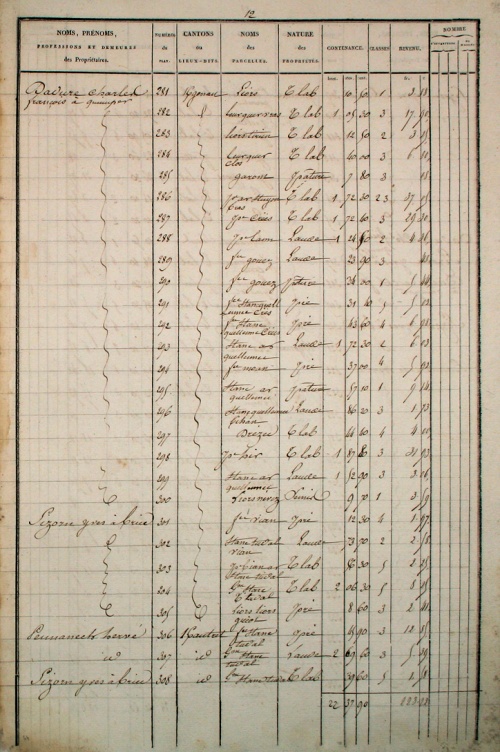 p.12 |
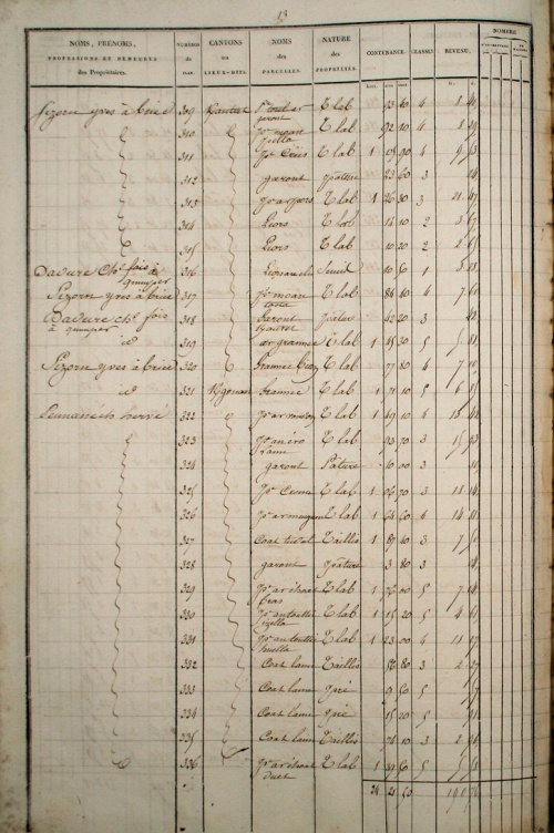 p.13 |
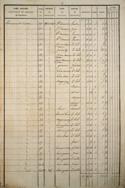 p.14 |
 p.15 |
 p.16 |
 p.17 |
 p.18 |
 p.19 |
 p.20 |
 p.21 |
 p.22 |
 p.23 |
 p.24 |
 p.25 |
 p.26 |
 p.27 |
 p.28 |
 p.29 |
 p.30 |
 p.31 |
 p.32 |
 p.33 |
 p.34 |
 p.35 |
 p.36 |
 p.37 |
 p.38 |
 p.39 |
 p.40 |
 p.41 |
 p.42 |
 p.43 |
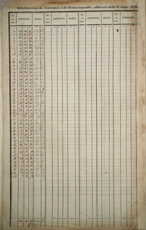 recap |
|||
| Section D - Niverrot | |||||
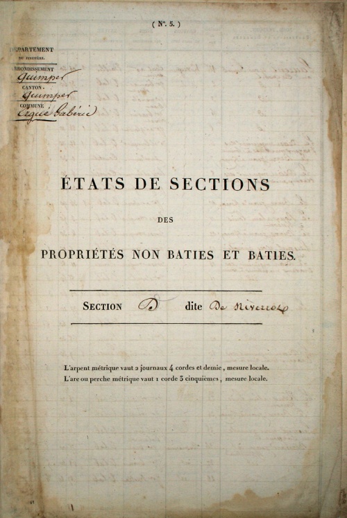 couv |
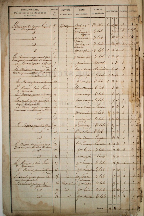 p.1 |
 p.2 |
|||
| Section E - Lokeltaz | |||||
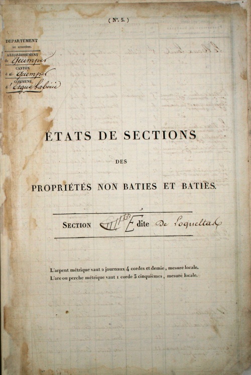 couv |
 p.1 |
 p.2 |
|||
| Section F - Bourg | |||||
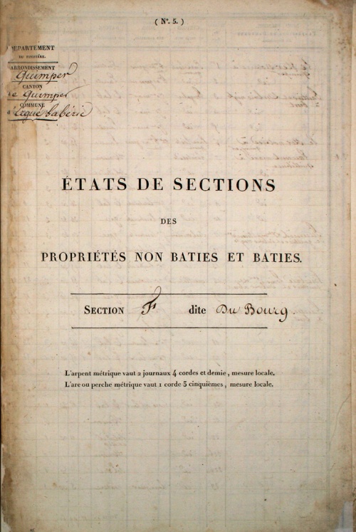 couv |
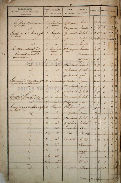 p.1 |
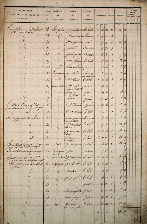 p.2 |
|||
| Section G - Lezergué | |||||
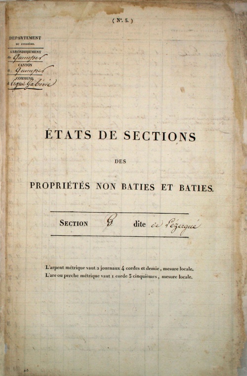 couv |
 p.1 |
 p.2 |
|||
4 Annotations
- Henri Chauveur est un expert généalogiste qui a relevé pour le compte du CGF (Centre Généalogique du Finistère) des quantités d'actes BMS (Baptèmes, Mariages, Sépultures) sur Ergué-Gabéric et Quimper. Outre son immense arbre généalogique sur geneanet.org, Henri a mené d'autres travaux de recherches historiques pour sa commune gabéricoise, publiés dans les bulletins de l'association Arkae et sur le site GrandTerrier : la création de la papeterie Bolloré, les émigrés de Saint-Chéron, les hameaux d’Ergué-Gabéric, les auvergnats gabéricois, le cadastre Napoléonéen de 1835 ... [Ref.↑]
|
Thème de l'article : Monographie d'un lieu-dit de la commune d'Ergué-Gabéric Date de création : Décembre 2016 Dernière modification : 27.12.2016 Avancement : |