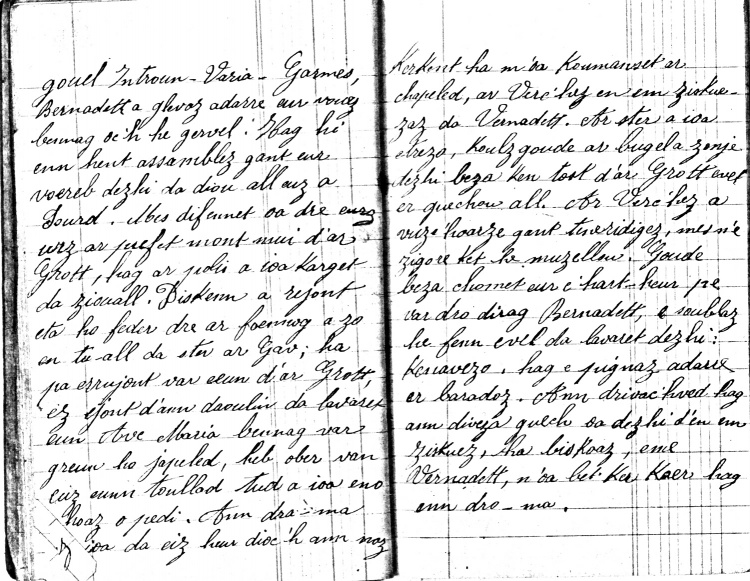
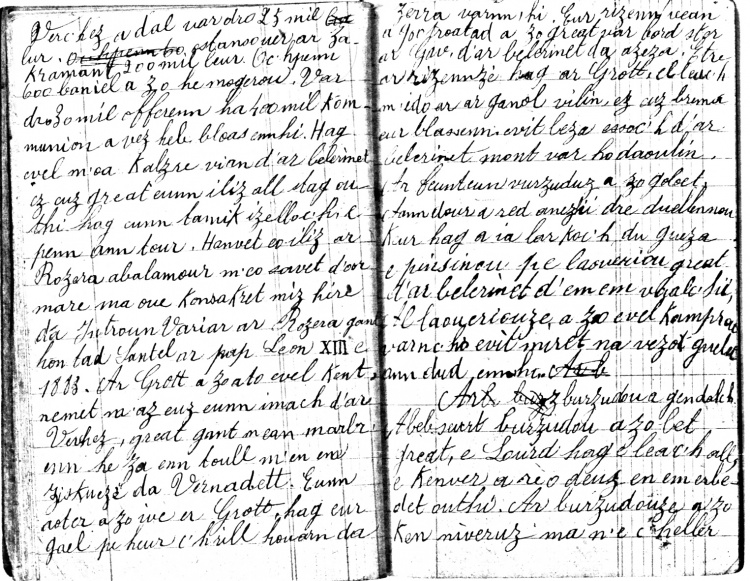
Essai
Un article de GrandTerrier.
(Différences entre les versions)
| Version du 30 novembre ~ miz du 2015 à 22:36 (modifier) GdTerrier (Discuter | contributions) ← Différence précédente |
Version actuelle (3 août ~ eost 2023 à 21:03) (modifier) (undo) GdTerrier (Discuter | contributions) |
||
| (122 intermediate revisions not shown.) | |||
| Ligne 1: | Ligne 1: | ||
| - | ==Introduction== | + | <gallery> |
| - | + | Image:Bursudou41.jpg | |
| - | {| width=870 | + | Image:Bursudou42.jpg |
| - | |width=48% valign=top {{jtfy}}| | + | Image:Bursudou43.jpg |
| - | <gmap3 f1="Cadastre1834-Sulvintin-F1" n1="f" x1=5002 y1=2458></gmap3> | + | Image:Bursudou44.jpg |
| - | |width=4% valign=top {{jtfy}}| | + | Image:Bursudou45.jpg |
| - | |width=48% valign=top {{jtfy}}| | + | Image:Bursudou46.jpg |
| - | -- | + | Image:Bursudou47.jpg |
| - | |} | + | Image:Bursudou48.jpg |
| - | + | Image:Bursudou49.jpg | |
| - | {|width=870 | + | Image:Bursudou50.jpg |
| - | |valign=top|{{StatutLogoCarte | avancement=2 }}__NUMBERHEADINGS__ | + | Image:Bursudou51.jpg |
| - | |valign=top align=left|__NOTOC__<i>On pourra consulter ici un outil de geolocalisation des villages sur le tableau d'assemblage du plan cadastral de 1834, ainsi que des liens vers des extraits des feuilles et des matrices cadastrales.</i> | + | Image:Bursudou52.jpg |
| - | + | Image:Bursudou53.jpg | |
| - | Autres lectures :{{Tpg|Origine du cadastre parcellaire Napoléonien|[Origine du cadastre parcellaire Napoléonien}}{{Tpg2|Parcellaire du cadastre de 1834 *|Parcellaire du cadastre de 1834 *}}{{Tpg2|:Category:Toponymie|Liste complète des toponymes français/bretons}}{{Tpg|Carte d'Etat-Major au 1:40000 établie en 1825-1866}} | + | Image:Bursudou54.jpg |
| - | |valign=top|[[image:CarteEG2.jpg|180px|right]] | + | Image:Bursudou55.jpg |
| - | |} | + | Image:Bursudou56.jpg |
| - | + | Image:Bursudou57.jpg | |
| - | <gmap3 f1="Cadastre1834" n1="e" x1=5665 y1=3177></gmap3> | + | Image:Bursudou58.jpg |
| - | + | Image:Bursudou59.jpg | |
| - | + | Image:Bursudou60.jpg | |
| - | ==Zoom sur le tableau d'assemblage== | + | </gallery> |
| - | <gmap f1="Cadastre1834" n1="e" x1=5665 y1=3177></gmap> | + | |
| - | + | ||
| - | ==Sections, feuilles et villages== | + | |
| - | {|width=870 | + | |
| - | |width=48% valign=top | | + | |
| - | *Section Bourg : | + | |
| - | **[ <u>[[Cadastre 1834 - Section du Bourg - Feuille 1 - Partie 1|Feuille 1 - Partie 1]]</u> ] [[Image:right.gif]] {{Tpg2|Géo.Kernévez#Cadastre_de_1834|Kernévez}}{{Tpg2|Géo.Lenhesq#Cadastre_de_1834|Lenhec'h}}{{Tpg2|Géo.Gongalic#Cadastre_de_1834|Congallic}}{{Tpg2|Géo.Kergaradec#Cadastre_de_1834|Kergaradec}} | + | |
| - | **[ <u>[[Cadastre 1834 - Section du Bourg - Feuille 1 - Partie 2|Feuille 1 - Partie 2]]</u> ] [[Image:right.gif]] {{Tpg2|Géo.Bourg#Cadastre_de_1834|Bourg}}{{Tpg2|Géo.Pennarun#Cadastre_de_1834|Pennarun}} | + | |
| - | **[ <u>[[Cadastre 1834 - Section du Bourg - Feuille 2|Feuille 2]]</u> ] [[Image:right.gif]] {{Tpg2|Géo.Kerampensal#Cadastre_de_1834|Kerampensal}} {{Tpg2|Géo.Cleuyou#Cadastre_de_1834|Cleuyou}}{{Tpg2|Géo.Cleuyou#Cadastre_de_1834|Moulin du Cleuyou}}{{Tpg2|Géo.Cleuyou#Cadastre_de_1834|Pont du Cleuziou}}{{Tpg2|Géo.Poulduic #Cadastre_de_1834|Poulduic }}{{Tpg2|Géo.Salleverte#Cadastre_de_1834|Salverte}}{{Tpg2|Géo.Botsuzic#Cadastre_de_1834|Bossuzit izella}}{{Tpg2|Géo.Botsuzic#Cadastre_de_1834|Bossuzit huella}}{{Tpg2|Géo.Mélénec#Cadastre_de_1834|Le Melenec}}{{Tpg2|Géo.Bodenn#Cadastre_de_1834|Boden}}{{Tpg2|Géo.Pennarun#Cadastre_de_1834| Moulin de Pennarun}} | + | |
| - | *Section Squividan : | + | |
| - | **[ <u>[[Cadastre 1834 - Section du Squividan - Feuille 1|Feuille 1]]</u> ] [[Image:right.gif]] {{Tpg2|Géo.Moulin_du_Poul#Cadastre_de_1834|Moulin du poul}}{{Tpg2|Géo.Griffonès#Cadastre_de_1834|Griffonès}}{{Tpg2|Géo.Kerbéron#Cadastre_de_1834|Kerberon}}{{Tpg2|Géo.Kernoas#Cadastre_de_1834|Kernoas}}{{Tpg2|Géo.Quélennec#Cadastre_de_1834|Quellennec}} | + | |
| - | **[ <u>[[Cadastre 1834 - Section du Squividan - Feuille 2|Feuille 2]]</u> ] [[Image:right.gif]] {{Tpg2|Géo.Kerourvois#Cadastre_de_1834|Kerourvois}}{{Tpg2|Géo.Pennervan#Cadastre_de_1834|Pennervan}}{{Tpg2|Géo.Squividan#Cadastre_de_1834|Squividan}}{{Tpg2|Géo.Kerfrès#Cadastre_de_1834|Kerfres}}{{Tpg2|Géo.Stanquéau#Cadastre_de_1834|Stanquéo}}{{Tpg2|Géo.Kervéady#Cadastre_de_1834|Kerviady}}{{Tpg2|Géo.Kerdudal#Cadastre_de_1834|Kerdudal}}{{Tpg2|Géo.Sulvintin#Cadastre_de_1834|Sulvintin}}{{Tpg2|Géo.Parc_Loch_Guen#Cadastre_de_1834|Parc loc'h guen}}{{Tpg2|Géo.Ti Bur#Cadastre_de_1834|Kerjenny}}{{Tpg2|Géo.Lézébel#Cadastre_de_1834|Lezébel}}{{Tpg2|Géo.Pennaros#Cadastre_de_1834|Penaros}} | + | |
| - | **[ <u>[[Cadastre 1834 - Section du Squividan - Feuille 3|Feuille 3]]</u> ] [[Image:right.gif]] {{Tpg2|Géo.Cleuyou#Cadastre_de_1834|Pont du Cleuziou}}{{Tpg2|Géo.Coutily#Cadastre_de_1834|Coutilly}}{{Tpg2|Géo.Kerelan#Cadastre_de_1834|Kerelan}}{{Tpg2|Géo.Pont Patra#Cadastre_de_1834|Pont patra}} | + | |
| - | **Feuille 4 [[Image:right.gif]] Tréodet ¤ Keranroux ¤ Squividan ¤ Le Lec ¤ | + | |
| - | *Section Sulvintin : | + | |
| - | **[ <u>[[Cadastre 1834 - Section de Sulvintin - Feuille 1|Feuille 1]]</u> ] [[Image:right.gif]] {{Tpg2|Géo.Odet#Cadastre_de_1834|Moulin à papier}}{{Tpg2|Géo.Beg Ménez#Cadastre_de_1834|Bec ar menez}}{{Tpg2|Géo.Kermorvan#Cadastre_de_1834|Kermorvan}}{{Tpg2|Géo.Keranguéo#Cadastre_de_1834|Keronguéo}} | + | |
| - | **Feuille 2 [[Image:right.gif]] Sulvintin ¤ Kerviady ¤ Pont al lenn ¤ {{Tpg2|Géo.Quélennec#Cadastre_de_1834|Quellennec izella}} ¤ Chapelle de St-Guénolé ¤ Pennanerc'h ¤ Munuguic ¤ | + | |
| - | *Section St-André : | + | |
| - | **Feuille 1 [[Image:right.gif]] Kerlaviou, Kerangoant, Crec'h-ergué, Moulin de Kergonan, Coat-piriou, Moulin de Coat-piriou | + | |
| - | |width=4% valign=top| | + | |
| - | |width=48% valign=top | | + | |
| - | **Feuille 2 [[Image:right.gif]] Kerautret, Parc ar franquic, Kersaux, Pont Alhuen, Kergonan | + | |
| - | **Feuille 3 [[Image:right.gif]] Kerouzel, Lestonan, Kerhuel, Kerho, Quillihouarn, Guillyvian, Guillyvras, Garshalec vras, Garshalec vian, Saint André, Kervoreden, Crec'hergué | + | |
| - | *Section Niverrot : | + | |
| - | **Feuille 1 [[Image:right.gif]] {{Tpg2|Géo.Balannou#Cadastre_de_1834|Balannou}} Savardiry ¤ Kerautret ¤ Carpont ¤ Trolan ¤ Mesnaonic ¤ | + | |
| - | **Feuille 2 [[Image:right.gif]] Kerganon ¤ Niverrot ¤ {{Tpg2|Géo.Kerdévot#Cadastre_de_1834|Kerdévot}} Keryann ¤ Kerlavien ¤ Carpont ¤ | + | |
| - | *Section Loqueltas : | + | |
| - | **Feuille 1 [[Image:right.gif]] Kerellou ¤ Lezouanac'h ¤ Castel ¤ Kermoysan ¤ Moulin pont ar marhat ¤ | + | |
| - | **Feuille 2 [[Image:right.gif]] Quenac'h Deniel ¤ Moulin du faou ¤ Keristin ¤ Rubernard ¤ Loqueltas ¤ Keranroué ¤ Méouet vian ¤ Méouet vras ¤ Kerveil ¤ | + | |
| - | **Feuille 3 [[Image:right.gif]] Keriou ¤ Moulin du Jet ¤ Kerdilès ¤ | + | |
| - | *Section Lezergué : | + | |
| - | **Feuille 1 [[Image:right.gif]] Moulin de Kernaou ¤ Kerdohal ¤ Kervernic ¤ Kernaon ¤ Quenecrasec ¤ Kerdalès ¤ Trolan ¤ Kerveguen ¤ | + | |
| - | **Feuille 2 [[Image:right.gif]] Moulin de Losts ar guillec ¤ Lost ar guillec ¤ Kergamen ¤ Bohars ¤ Penn ar menez ¤ Mesanlez ¤ Kernaou ¤ Kerampelliet ¤ Kerdalès ¤ Kerourvois Kerdévot ¤ {{Tpg2|Géo.Kerdévot#Cadastre_de_1834|Kerdévot}} | + | |
| - | **Feuille 3 [[Image:right.gif]] Lezergué ¤ Quillihuec ¤ Kervian ¤ Kerfor ¤ Moulin de Kerfor ¤ Parc al lan ¤ Kervinic ¤ Kernaou ¤ Kervreyen ¤ | + | |
| - | |} | + | |
Version actuelle
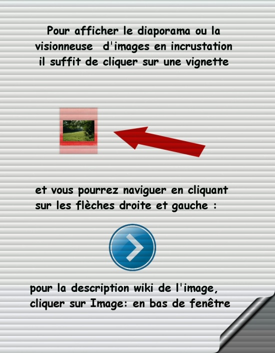 Diaporama Diaporama | |||||
 |
 |
 |
 |
 |
 |
 |
 |
 |
 |
 |
 |
 |
 |
 |
 |
 |
 |
 |
 |
||||